


Paths, Walks and Trekking

Slide title
Scrivi qui la tua didascaliaButton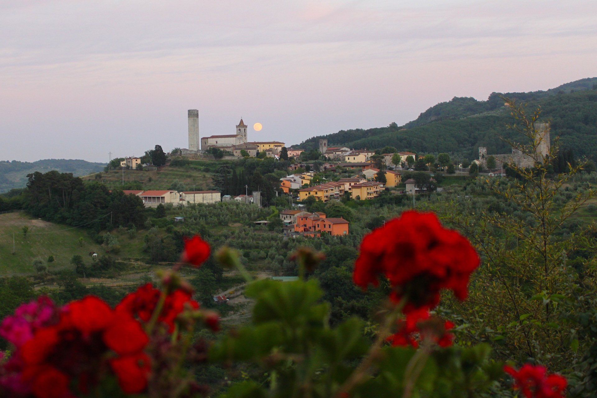
Slide title
Scrivi qui la tua didascaliaButton
Slide title
Scrivi qui la tua didascaliaButton
-
Walk from Agriturismo I Pitti to Serravalle Pistoiese
The village of Serravalle from which we enjoy a beautiful view from our house that varies almost at every hour of the day, can be easily reached on foot.
The walk begins on the dirt road via Pitti (700 meters) up to Via di Cagnano, continue to the right and then along via Pace for the steep climb that leads to the small village.
You can then explore the towers of the ancient fortress. On one of the towers it is possible to climb and observe the splendid view which can be enjoyed. Also try to identify our farmhouse from the top of the tower: it is not difficult to recognize it.
You can then take a tour of the village, among the narrow and characteristic streets and if you are lucky enough to find one of the two open churches, take a peek inside: you can savor the quiet and intimate atmosphere they instill.
The walk up to the towers takes approximately 25 minutes.
Walk from the Agriturismo i Pitti towards Serravalle Pistoiese
4/6/2021
Slide title
Scrivi qui la tua didascaliaButton
-
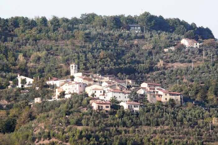
Walk from Agriturismo i Pitti to La Castellina
This walk leads to the village Castellina which is located 380 meters above sea level. It is therefore a walk with some uphill sections, but easy to walk.
Starting from the farmhouse, go along the entire dirt road Via Pitti to the Via Cagnano. Instead of turning right as is usually done for a daily excursion, turn left and continue along the road, always remaining on the main route.
The road is partly paved and partly unpaved, for public transit, and at a certain point you also cross a small private zoo of a person who loves to breed animals of various species such as peacocks, geese, llamas, pigeons, etc. These animals can be seen quite well from the street and consider that the person who raises them does not like being approached for fear of frightening the animals.
The walk to Castellina takes about 1 hour and a half.
Walk from the Agriturismo I Pitti towards Castellina
4/6/2021
Titolo diapositiva
Scrivi qui la tua didascaliaPulsante
-
Hike from Agriturismo I Pitti – San Baronto
Hike from Serravalle P.se – San Baronto (CAI Trail 800)
The hike follows almost the entire ridge of the Montalbano mountains in the Pistoia area, intersecting with CAI trails on the south and north slopes of the mountain range, offering wide views of the lower Valdarno, the Padule marsh, and the Ombrone valley.
Starting from Agriturismo i Pitti, walk along Via Pitti, and continue until the provincial road to reach Serravalle Arco (altitude 127 m), taking the CAI trail 800 which marks the entire route. The path alternates between some paved sections and dirt tracks, featuring continuous ups and downs. Along the way, you will encounter trail 821A (which descends to join trail 821 that runs from Masotti to Vinacciano), and after passing the ruins of C. Selmi (409 m), you proceed past an abandoned house (C. Fuso) and reach a viewpoint with a panoramic view of the Padule. The trail then meets trail 830 coming from Monsummano Alto.
After passing Casa Ronconi (423 m), you’ll find trail 817 on the left, coming from Cantagrillo-Vinacciano. A short descent leads to Case Topi (Agriturismo Poggio dei Papi, 300 m), followed by a gentle descent to a group of abandoned houses (C. Montirici, 271 m) near the provincial road (SP 27, which connects Cantagrillo with Montevettolini and Monsummano T).
Continuing, you will reach an important junction of trails, 830 and 826, which turn right towards Montevettolini and Cecina-Larciano respectively. Our trail, however, climbs straight up a steep and challenging path, reaching the summit of M. Cupoli. Skirting vineyards in a scenic location, it descends to intersect with provincial road 28 (which connects Cantagrillo with Biccimurri) at Casa al Vento (310 m).
Continuing, the path alternates between paved and dirt sections, passing through Mungherino and then the Nardini area, where trail 822 begins, leading to Larciano Castello. The hike proceeds on trail 800, skirting the "Barco Reale" campsite on the right and then, after a short descent, reaching S. Baronto. From the village, trail 820 begins, descending towards Spicchio and Lamporecchio.
The CAI 800 trail then descends to the left of the Church, crosses SP 9 (Via Montalbano), and continues towards the Torre di S. Alluccio and beyond.
Itinerary Details
- Elevation gain/loss: 550 m ascent / 320 m descent;
- Duration: approx. 5:40 hours (excluding breaks);
- Length: approximately 14 km.
Hike from Agriturismo I Pitti – San Baronto
11/10/2024
Titolo diapositiva
Scrivi qui la tua didascaliaPulsante
-
Walk from Agriturismo i Pitti to Vinacciano
Walk from Agriturismo i Pitti to Vinacciano
- Length: 7 km (one way)
- Time required: outbound 2 hours 30 minutes, return 2 hours
- Elevation gain: 200 m ascent, 50 m descent
Starting from Agriturismo i Pitti, follow Via Pitti until you reach the provincial road and continue to Serravalle Arco (altitude 127 m). Near the locality Arco di Serravalle, take Via Monte. The CAI 800 trail markers are clearly visible on the wall, indicating the directions to Case Fermi, Case Montirici, and San Baronto. Continue uphill on asphalt for 750 meters, then turn right onto Via Poggio Cala along the CAI 800 trail. Follow the path until the end of the paved road, keeping to the right on a small dirt road lined with a double row of oak trees. After a gentle climb, at the junction with a cart track, keep left and continue to follow the CAI white and red markers, turning right uphill on a paved road near a hairpin bend.
You will soon come across the Casetta-Niconi farm, a beautiful stone complex in an excellent location. Continue straight, and shortly after, at a junction with CAI signage, turn left onto trail 821A. After 900 meters, at the next junction, stay left and descend through a dense forest, primarily composed of pine, chestnut, and black locust trees.
After about 300 meters, at the next significant junction, continue right, leaving trail CAI 821A. Proceed downhill for another 500 meters, starting with a stony section, then onto a flat stretch, crossing two small streams (usually dry during the summer) until you exit the forest and meet a wide cart track. Turn left until the end of the dirt road and then right to quickly reach the small village of Vinacciano. From the small square in front of the church, you can enjoy a wide view over the city and the plain below.
Walk from Agriturismo i Pitti to Vinacciano
11/10/2024
Titolo diapositiva
Scrivi qui la tua didascaliaPulsante
Titolo diapositiva
Scrivi qui la tua didascaliaPulsante
-
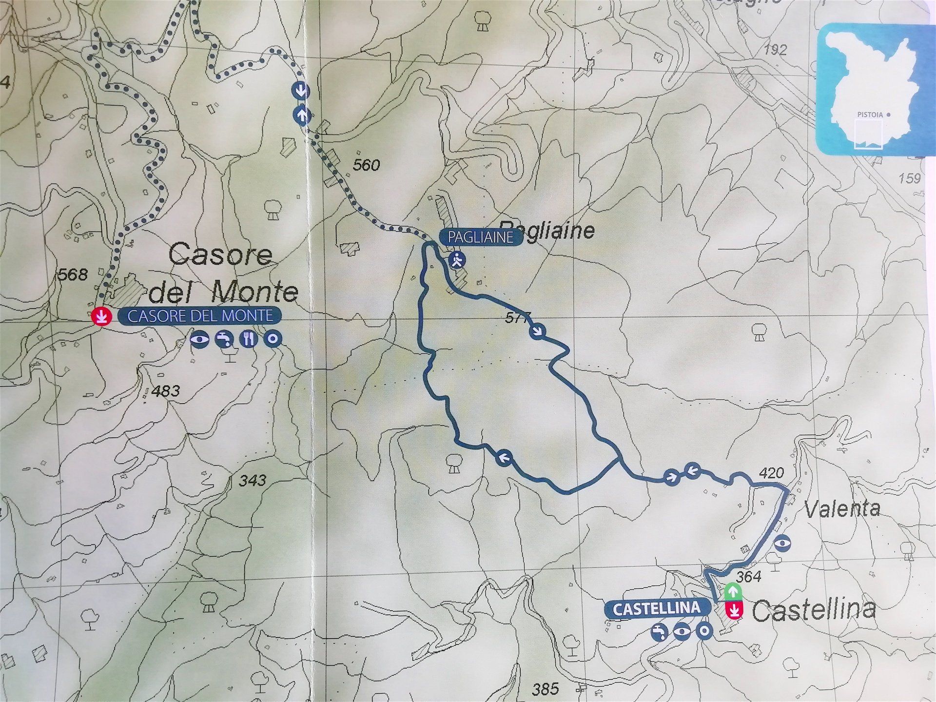
Trekking Castellina - Casore del Monte
Il borgo di Castellina può essere raggiunto dall’Agriturismo I Pitti a piedi oppure in automobile.
Dalla piazza della chiesa di Castellina (m.365) si procede in salita in via Valenta e dopo circa 700 metri, con l’ultimo tratto pianeggiante, si svolta a sinistra. Dopo poche decine di metri a destra entriamo nel bosco. Seguiamo la carrareccia principale inizialmente in falsopiano e poco dopo in salita e, percorsi circa 600 metri, ignorando il segnalino bianco-rosso a dritto, si prosegue a sinistra in leggera salita su terreno sassoso e successivamente in falsopiano con fondo sabbioso.
Recentemente questo tratto di strada sterrata è stato ampliato e consente di poterlo percorrere agevolmente, pertanto ignoriamo i sentieri laterali e continuiamo osservando ai lati arbusti di erica, felci, ginestre, corbezzoli e agrifogli. Al successivo bivio teniamo la destra e continuiamo a seguire la strada principale con fondo più compatto. Questo tragitto attraversa un bosco con castagni e pini fino ad arrivare alle prime case ed in breve alla strada asfaltata in località Pagliaine (m. 540). A questo punto ci sono due alternative:
1 ) tornare al luogo di partenza. In questo caso voltare a destra in salita e poco dopo, al termine della strada asfaltata, entrare ancora nel bosco e seguire i segnali bianco-rossi, prima in discesa e poi in prossimità di un rudere, in falsopiano, fino a incrociare nuovamente il bivio incontrato durante il percorso dell’andata. Da qui ripercorrere a ritroso lo stesso tragitto fino alla piazza della chiesa di Castellina;
2) proseguire fino a Casore del Monte. voltare a sinistra su strada pianeggiante e oltrepassare il bivio per l’“Associazione Nuovi Orizzonti”. Percorrere interamente via Castellina fino all’incrocio con la strada principale. Da qui voltare a sinistra per circa km 2,5 fino alla località Casore del Monte (m.560). Per il percorso di ritorno tornare sullo stesso percorso a Pagliaine e da qui seguire le indicazioni dell’alternativa 1).
-
Route Details
Climbing difference in height: 195 m.
Lenght: km. 3,5 to Pagliaine (there and back km 7) km 6 to Casore del Monte (there and back km 12)
Time: 1 hour (there) 2 hous back up to Pagliaine, 1,5 hous there and 3 hours there and back to Casore del Monte
Type of pathway: dirt road (excluding the first 700 meters of asphalt and 2.5 km of asphalt to reach Casore del Monte)
Equipment: camera, flask
Starting point: From Castellina (Serravalle Pistoiese Municipality) Church Square
Level of difficulty: easy, suitable for everyone
Notes: passable all year on foot
Presence of fountains only in Castellina and Casore del Monte
Trekking Castellinba - Casore del Monte - description and features of the trail
6/9/2021

Titolo diapositiva
Scrivi qui la tua didascaliaPulsante
-
Via Corta (Via Crucis) from Montecatini Terme to Montecatini Alto
From Montecatini Terme, it is possible to reach the original historic village, Montecatini Alto, on foot by following the ancient mule track, offering not only a historical but also an artistic route.
The path is in fact a Way of the Cross, marked by a series of old chapels that were restored in 1995 and enhanced with 14 fine ceramic reliefs donated by the Ceramic School of Montelupo.
Along Viale Diaz, just before reaching the funicular station to Montecatini Alto, turn right into Via del Castello (marked as hiking trail “A”), a paved lane that leads to a fork.
Continue left on the dirt path, then turn right shortly after to begin a steeper climb. Already in this initial stretch, you’ll encounter the elegant chapels of the Way of the Cross. The wide path ascends steadily, runs alongside the funicular for a while, and after a stairway section, enters a rural landscape mostly characterized by terraced olive groves.
Returning to follow the funicular, the panorama opens up gradually, offering views both of the Pescia plain and the Fucecchio Marshes, as well as the historic hilltop village of Montecatini Alto.
With a final climb, you arrive at the paved road that leads, to the left, through one of the ancient gates into the historic center of the village.
The return route follows the same path as the ascent.
Via Corta (Via Crucis) from Montecatini Terme to Montecatini Alto
13/7/2025

Slide title
Scrivi qui la tua didascaliaButton
-
Vinci - Strada Verde - Green Path between Vinci and Leonardo's birthplace in Anchiano
The coutryside surrounding Vinci and the House in Anchiano are undoubtedly the first great source of inspiration for young Leonardo. The wooded slopes of Montalbano which, today like then, transform first into olive groves and then into vineyards, are unique to this landscape, background to the childhood of the Genius. To enter this nature means to travel back in time and to find yourselves in the young artist’s shoes when he first started to empyrically observe the nature and its elements, and to follow into his footsteps.
The path begins at the Strada Verde(Green Road), itinerary n. 14, the 2 km path that connects Vinci to Leonardo’s house. The itinerary explores them typical Tuscan countryside, with its distinctive terracing and fields of olive trees and vineyards, and it retraces an old path, known in the 1800s as Via Botanica. This same road was usually walked by Giuseppe Garibaldi, leaving the Fattoriadel Ferrale, when he was a guest of Count Masetti in 1867. As noted by historian Gustavo Uzielli, the Hero of the Two Worlds used to “wake up at 4 inthe morning, take a cold shower and then, through the Via Botanica, walked to Leonardo’s House in Anchiano to gather some of that great man’s Genius forhimself”.
Today, the Strada Verde is a very evocative hiking trail for those who want to reach Leonardo’s House and enjoythe beautiful views of Vinci and the Tuscan countryside, and it is walked every year by thousands of visitors in search for the origins of the Genius. Along this path, half way between Vinci and Anchiano, you can find a fork leading to the 1400s pescaia, used for centuries to regulate the water flow for the canal which powers the Mulino della Doccia near Vinci. A map of that same Mill is sketched by Leonardo in an early 1500s drawing (Codex Atlanticus, 765r, Milan, Biblioteca Ambrosiana).
Details:
Path’s lenght: 1800 mt
Type of path: foot, bike
Road surface: dirt road, with somepaved sections
Difficulty: easy, medium declivity
4/6/2021
Vinci - the Strada Verde - Green path between Vinci and Leonardo's birthhouse in Anchiano
Titolo diapositiva
Scrivi qui la tua didascaliaPulsante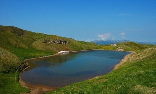
Titolo diapositiva
Scrivi qui la tua didascaliaPulsante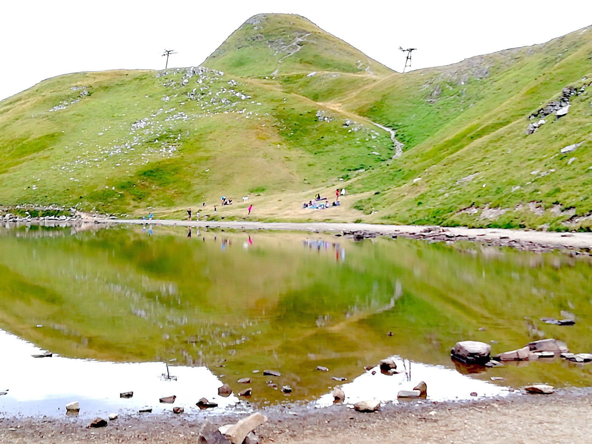
Titolo diapositiva
Scrivi qui la tua didascaliaPulsante
Titolo diapositiva
Scrivi qui la tua didascaliaPulsante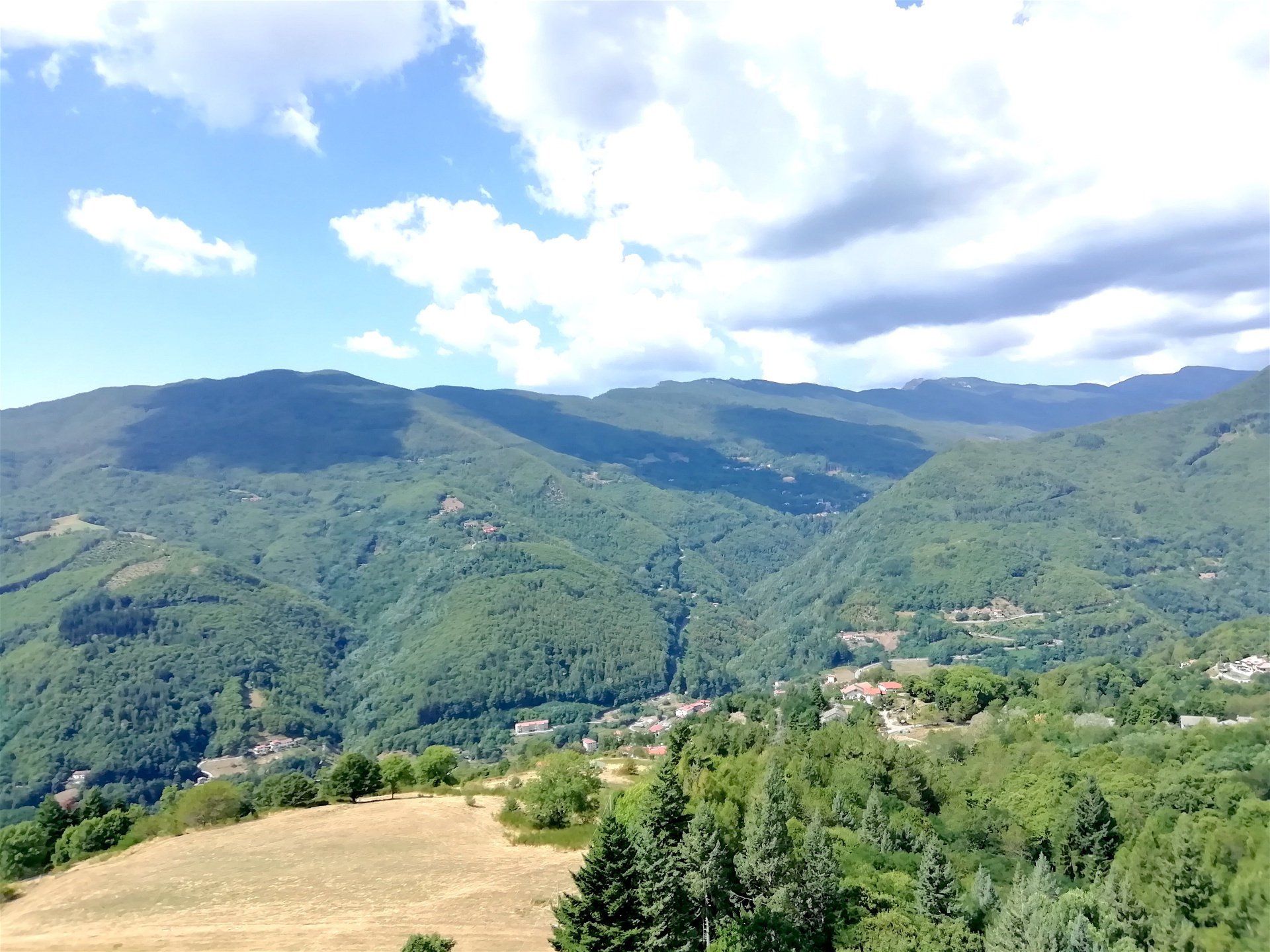
Titolo diapositiva
Scrivi qui la tua didascaliaPulsante
Titolo diapositiva
Scrivi qui la tua didascaliaPulsante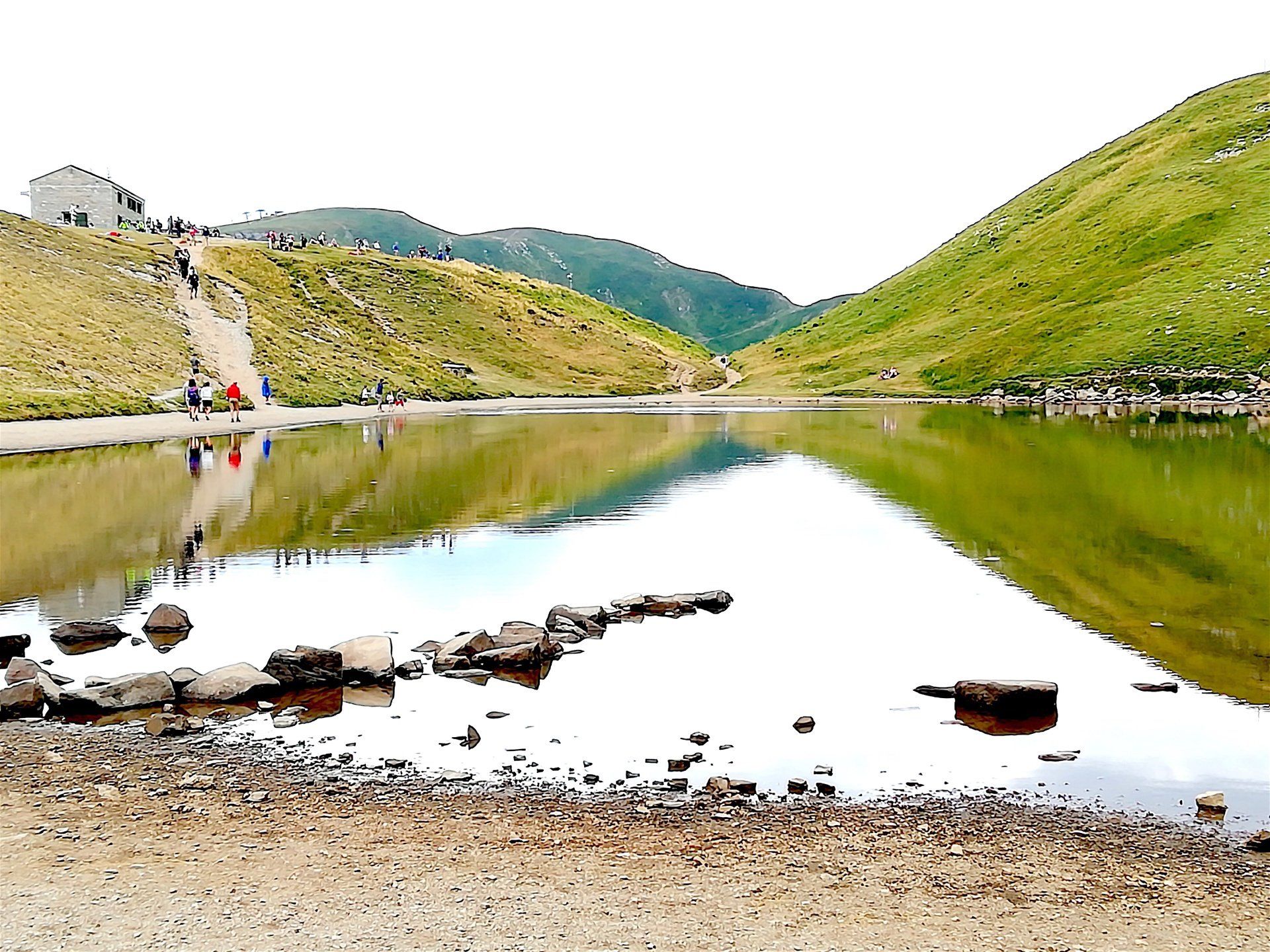
Titolo diapositiva
Scrivi qui la tua didascaliaPulsante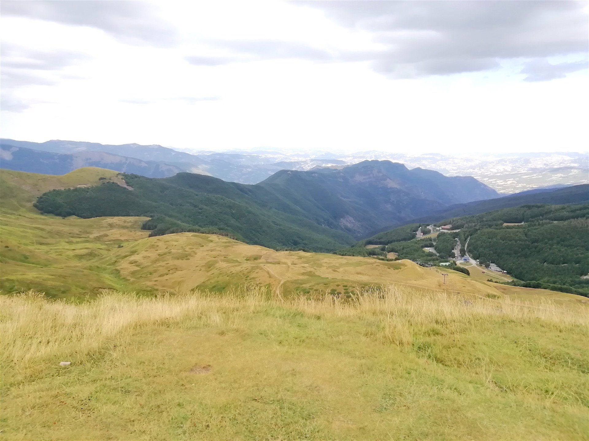
Titolo diapositiva
Scrivi qui la tua didascaliaPulsante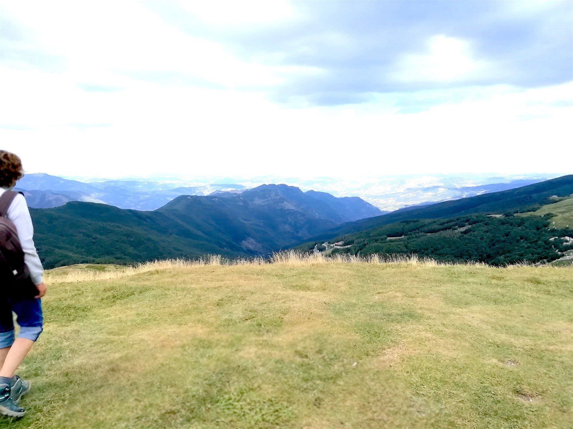
Titolo diapositiva
Scrivi qui la tua didascaliaPulsante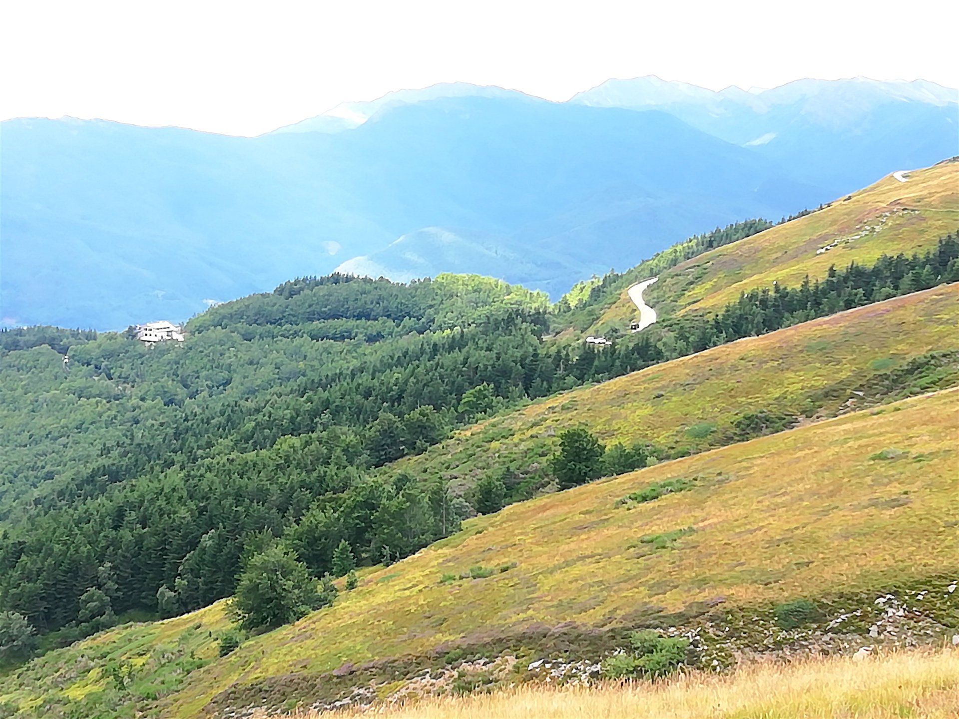
Titolo diapositiva
Scrivi qui la tua didascaliaPulsante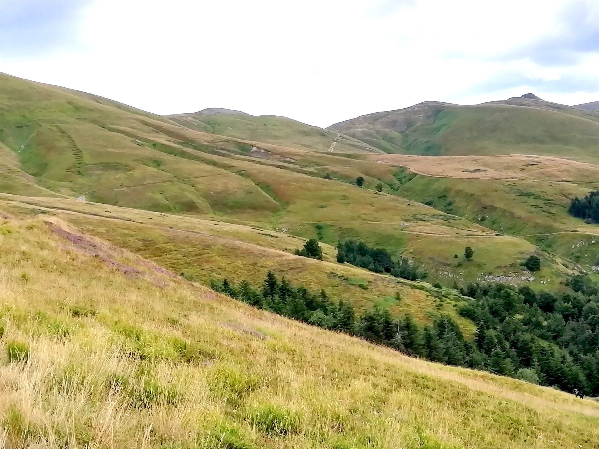
Titolo diapositiva
Scrivi qui la tua didascaliaPulsante
-
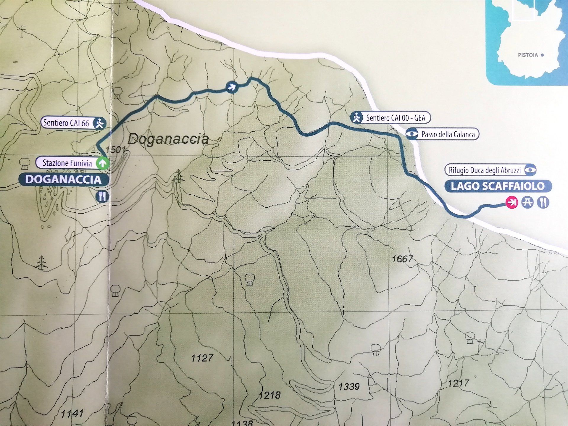
Trekking Itinerary Doganaccia - Lake Scaffaiolo
It is a very pleasant itinerary for trekking lovers, ideal to escape from the hot days in the plain, a way to spend a day that is a little different from the usual.
I recommend taking the walk with suitable shoes and clothing that can also protect against the summer showers that can occur almost unexpectedly, especially in the months of July and August.
La Doganaccia (1547 m.) can be reached by car driving for about 14 km after Cutigliano, or taking the cableway from Cutigliano.
The itinerary starts from the little church near the arrival station of the cableway. Once there, take the red-and-white signaled path, and, after walking under the chairlift, take the steep slope on your right. (On your left you will see the path that leads to the Croce Arcana Mountain and the "faggio di Maria" ("Mary's beech”), a big solitary beech-tree dominating over the Doganaccia. From here you can enjoy a wonderful view of the ridges of the Apennines, from the Libro Aperto and the Cimone on the western side, to the Cornacelo and Mount Gennaio on the eastern side.)
You will meet a dirt road near a ditch, cross it and keep walking on the path that cuts the southern versant of Mount Spigolino. After you reach the spring (where you can fill up your flasks), keep climbing and you will soon find the CAI path 0-0 near the Calanca Pass (1737 m.). Before 1789 this pass was known as "Calanchetta" in order to distinguish it from the Calanca Pass that was set between Mount Cupolino and the Cornacio and that is nowadays called "dei Tre Termini". According to some historians, Hannibal and his army crossed this pass in the spring of 217 a.C. The Carthaginian commander, who was returning from the battles in the North of ltaly during which he had lost an eye, crossed this pass on the back of the only elephant that survived the war.
Continue eastward and you will reach, in about half an hour, lake Scaffaiolo (1775 m.), one of the most beautiful natural lakes of Northern Appenines.
The origin of the Lake has been long debated. Different and bizzarre hypothesis were presented: from a volcanic origin ( but there are no volcanic rocks in the area), to the existence of canals which fed the lake directly from the sea. The name “Scaffaiolo” seems to derive from “Scaffa” (basin), which may explain the origin of the lake. The waterproof rocks, typical of this area, retain the water gathered in the small basin (only a few hundred meter wide) formed by Mount Cupolino. The absence of any kind of vegetation, due to the height, has prevented it from being slowly covered with earth. However, recent climate change has significantly reduced its size.
Close to the Lake Scaffaiolo there is the Duca degli Abruzzi refuge which offers a pleasant lunch point with polenta or pasta with meat sauce, mushroom sauces etc. and both cold and hot drinks.
It is open from 12 am to 3 pm and from 7 pm to 8.30 pm from June 15 to September 15 with room and board service. For the rest of the year open every weekend except November, the month of annual closure. During the holiday period at the turn of the year, the refuge is open from December 26th to the Epiphany. During the Easter period the Refuge remains open for a week.
Refuge tel.nr.: +39 534 53390
Antonio Tabanelli: 3477129414
Lucia Ceron: 3384884782
Mirco Mori: 3275705234
-
Route Details
Climbing difference in height: 250 m.
Lenght: 8 Km. (there and back)
Time: 1 and 1/2 hour (there) 60 minutes (back)
Type of pathway: mountain track
Equipment: binoculars, camera, mountain boots, waterproof cape, flask
Starting point: Doganaccia cableway parking
Signs: CAI paths n. 66 and n. 0-0, with red-and-white signs
Level of difficulty: average
Trekking Doganaccia - LagkeScaffaiolo - description and features of the Itinerary
19/8/2021
Titolo diapositiva
Scrivi qui la tua didascaliaPulsante
-
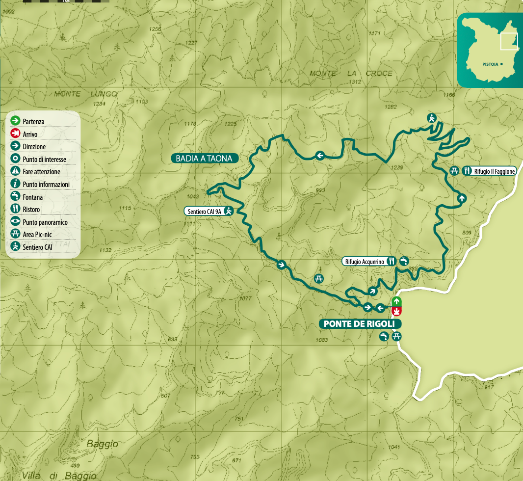
Trekking in the Biogenetic Nature Reserve of Acquerino
Biogenetic Nature Reserve of Acquerino
This trail is part of the Acquerino State Forest, covering 3,146 hectares in the municipalities of Sambuca Pistoiese, Pistoia, and Montale. It is the largest forest complex within the Pistoia State Forests. Despite the presence of several forestry tracks, the area retains an untouched, inaccessible feel, making it extremely beautiful and evocative. Beech trees dominate almost all the slopes. In many areas, afforestation with Norway spruce, black pine, Douglas fir, and other conifers has taken place, and numerous high-trunk beech conversions have been carried out.
Route description
Start at Ponte dei Rigoli (840 m), where the “Acquerino Biogenetic Nature Reserve” begins. Pass through the barrier at the edge of the parking area beyond the fence delimiting the large meadow. Proceed along the dirt forestry track (route no. 1 – educational trail by the State Forestry Corps), running alongside the Limentrella Orientale stream. After approx. 400 m, make a U‑turn and take the first uphill track on the right. Continue along the wide main track, which leads gently uphill into a spruce forest. Near a waterfall with a small bridge, continue straight uphill, cross a stream, and climb a few steps next to a fence to reach the asphalt road. Turn right downhill towards the State Forestry Corps station, then head left with a slight rise, flanked by a row of thuja trees, until you reach the Rifugio Acquerino restaurant (2.5 km).
Pass through the barrier, head in the direction of Rifugio Faggione, and at the first fork follow the “Deer Trail”, named for the chance to spot deer and other ungulates. Along the way, educational signs present information on the reserve’s fauna and flora. The path crosses an impressive spruce forest and, after a level-to-downhill stretch, you reach the fork that quickly leads left to Rifugio Faggione (995 m) at about 5 km — a picnic- and refreshment-friendly refuge open only in summer.
Continue past the refuge on CAI route 17–11, which winds through beech and spruce forests with wide switchbacks uphill to 1,120 m, where the wide forestry track ends. From there, a steep narrow path continues uphill to the right. Soon you’ll meet the trail from Torri and proceed left on a level section. Upon reaching 1,200 m at a plateau with a crossroads, ignore the right and left paths and continue downhill, veering slightly right, following the red-and-white CAI signs.
The trail continues across a steep slope, alternating level and slight ascents, crosses a stream, and reaches the Trogoli aqueduct intake (1,120 m, ca. 8.5 km). From here, after about 1 km, you reach the asphalt road near Badia a Taona and head left downhill. At the next fork, marked by the municipality border of Sambuca, go left for a short asphalt section before veering right onto CAI trail 9A, marked by a barrier and a sign indicating an ancient early medieval route. This final downhill stretch crosses a stream and passes by an ancient settlement that is part of the Ecomuseum, then winds along the Limentrella Orientale stream again until returning to the starting point at Ponte dei Rigoli.
-
Route Details
Starting point: Acquerino – Ponte dei Rigoli (840 m)
How to get there: From Pistoia, take Via Antonelli to Candeglia, then turn right toward Valdibure–Acquerino. After about 20 km on SP24 Riola you’ll reach Ponte dei Rigoli, near the Sambuca Pistoiese border sign. Park immediately after the bridge on the left near a large meadow.
Total length: 13 km (circular route)
Terrain: almost entirely dirt trail
Difficulty: easy and suitable for all up to Rifugio Faggione (5 km); the subsequent section is fairly challenging
Notes: Walkable year‑round, although not advisable in bad weather (snow likely in winter). The Faggione–Badia a Taona segment is demanding for mountain biking.
Trekking in the Biogenetic Nature Reserve of Acquerino
19/8/2021
8/7/2025
